
The Eye of Africa: A geological dome that reveals Earth's history from space
A unique location in the heart of the desert
Written by Omnia Hassan
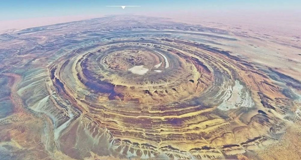
In northwestern Mauritania, the Sahara Desert is centered on a giant circular structure known scientifically as the Richat Structure and nicknamed the «Eye of Africa.» It has a diameter of about 50 kilometers and is clearly visible from space, making it a familiar navigational landmark for astronauts for decades. However, its true value goes beyond its striking shape; it is an open geological record documenting millions of years of Earth’s history in this part of the continent.
From the meteorite hypothesis to the interpretation of the rock dome
For many years, it was believed that the structure was a massive meteorite crater, but geological research settled the debate, as no known signs of impact such as metamorphic minerals or a clear impact center were detected.
A massive rock dome rises due to volcanic activity.
Instead, scientists believe that the «Eye of Africa» is the product of a complex geological evolution that began with the rising of a huge rock dome due to deep igneous activity within the Earth’s crust, followed by fracturing and erosion processes that revealed its layers in the form of overlapping rings.
Two-stage magmatic activity
Studies indicate that the region experienced two major phases of magmatic activity, separated by about 100 million years.
This resulted in various igneous intrusions including gabbro, carbonatite and sometimes kimberlite, which are indicators of deep magma movements in the Earth's interior. Over time, the cracks contributed to weakening the structure, and erosion later took over to highlight the distinctive ring-shaped gradient.
When the desert was rivers
The Sahara Desert has not always been barren. During humid climatic periods in the distant past, running water and seasonal rivers played a crucial role in shaping the surface.
This stage contributed to widening the valleys and cracks between the rock layers, and revealed the circular formations more clearly. Then the winds in later eras came to complete the shaping process, giving the landscape its current features.
Open Geological Laboratory
Today, the «Eye of Africa» is a natural laboratory that allows scientists to track the evolution of the Earth’s crust and the history of igneous activity in the west of the continent. It is an open archive that preserves details of rock formation, magma intrusions, and the effects of erosion and ancient climate with rare accuracy.
Although some details of its formation are still being researched, this geological dome remains an exceptional testament to the interaction of the Earth's deep forces with surface factors over millions of years.